Už ribų: Integruokite DI paremtą žemės intelektą į savo darbo eigą
Paverskite pasaulinius palydovinius duomenis praktiškai pritaikomomis įžvalgomis naudodami vieną keičiamo mastelio API.
Suteikite sistemoms galios naudodami patikrinamus faktinius žemės duomenis (Ground Truth)
Paverskite sudėtingus signalus naudingais duomenimis, kad automatizuotumėte žemės stebėjimą ir išvengtumėte spėlionių.
Visuotinis mastelis be jutiklių
Didelio tikslumo skiriamoji geba
Dažni atnaujinimai
14+ specializuotų rodiklių: pasėlių sveikata, vandens stresas ir žemės potencialas
FarmiSpace API nuorodos ir vartotojo vadovas
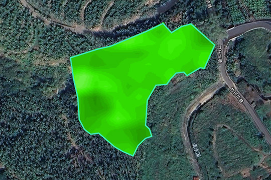
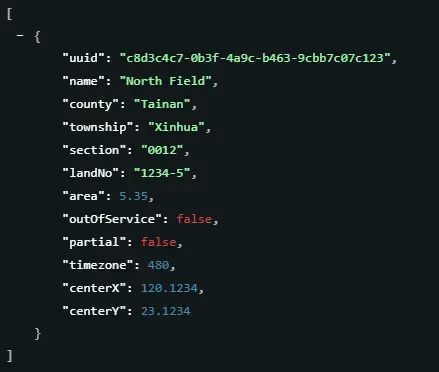
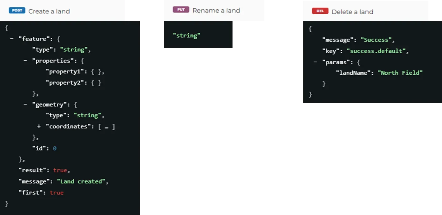
Ūkių ir žemės valdymas
Turto skaitmeninimo pagrindas
Paverskite geografines ribas į standartizuotus duomenų turtus, palaikydami viską nuo GeoJSON importavimo iki gyvavimo ciklo valdymo.
Pagrindinės funkcijos :
- Prieiga prie erdvinių metaduomenų visoms registruotoms žemėms.
- Standartizuota API žemės kūrimui, pervardijimui ir ištrynimui.
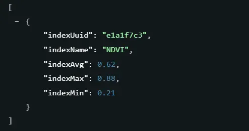
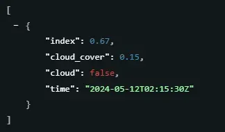
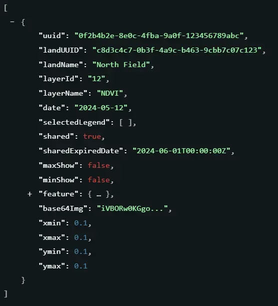
Indeksų duomenys
Kiekybinis pagrindas sprendimų priėmimui
Paverskite stebėjimo dažnumą analizuojamais laiko juostomis ir statistinėmis matricomis, kad palaikytumėte tendencijų sekimą ir anomalijų aptikimą.
Pagrindinės funkcijos :
- Stebėjimo laiko juosta: Filtruokite prieinamų duomenų datas konkrečioms žemėms ir indeksams.
- Statistinė matrica: Gaukite Min/Maks/Vid reikšmes, kad paverstumėte vaizdus į praktiškai pritaikomus skaičius.
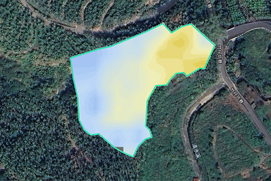
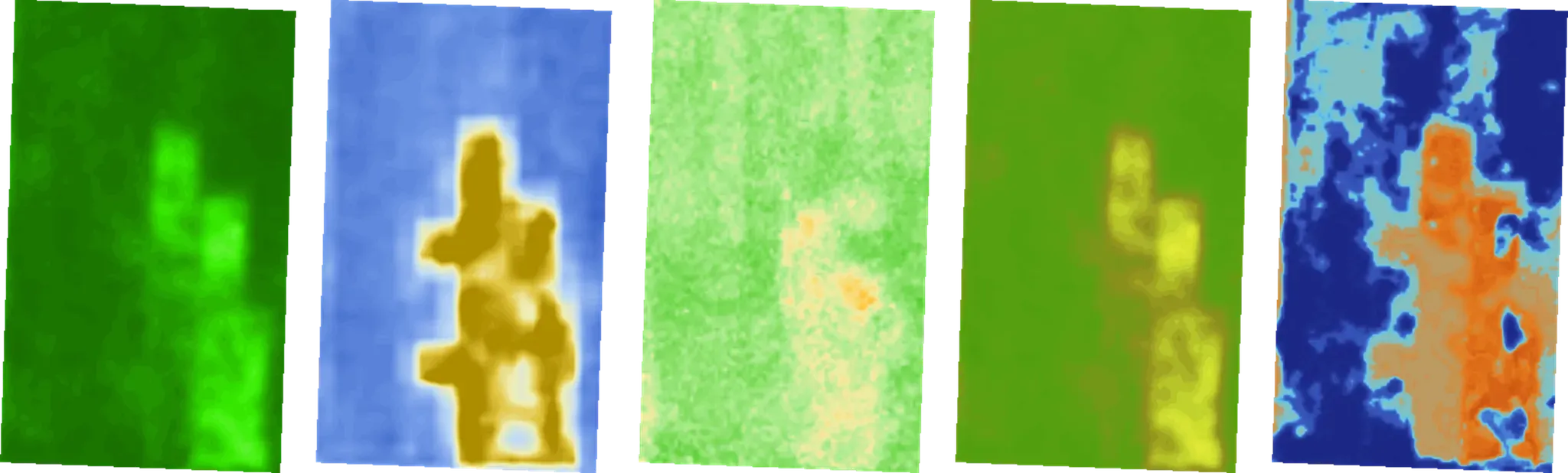
Indeksų vaizdai
Vizualinių ir neapdorotų duomenų sinergija
Gaukite prieigą prie 1 m x 1 m tinklelio skiriamosios gebos tiek intuityviam rodymui, tiek profesionaliai analitikai.
Pagrindinės funkcijos :
- Gaukite didelės skiriamosios gebos vaizdus konkrečioms datoms ir indeksams.
- Palaiko tiek vaizdinį RGB atvaizdavimui, tiek neapdorotą GeoTIFF neapdorotų duomenų analizei.
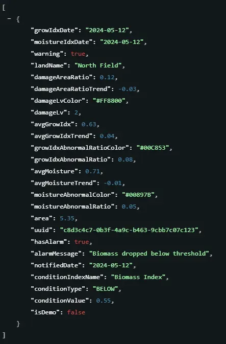
Tendencijos ir įspėjimai
Nuo stebėjimo iki prognozavimo
Filtruokite anomalijas ir sekite ilgalaikes tendencijas, kad paverstumėte didžiulius duomenis laiko atžvilgiu jautria rizikos informacija.
Pagrindinės funkcijos :
- Išmanusis įspėjimas:Nustatykite laukus, į kuriuos reikia atkreipti dėmesį, remdamiesi naujausia įspėjimo būsena.
- Sekite indekso tendencijas nurodytame datų diapazone laiko eilučių analizei.
Lauko stebėjimo užrašai
Faktinių duomenų sinchronizavimas
Visos „FarmiTag“ anotacijos, skirtos paskyrai priklausančioms žemėms, įskaitant užrašų informaciją, nuotraukas ir erdvines vietas.
Pagrindinės funkcijos :
- Virtuali ir reali integracija :Sinchronizuokite lauko užrašus („FarmiTags“) ir nuotraukas tiesiai į savo skaitmeninius žemėlapius.
- Suderinama su GIS :Vizualizuokite kenkėjų problemas ar augimo etapus su tikslia geografine vieta.
Narys ir paskyra
Prieigos kontrolė ir išteklių optimizavimas
Prenumeratų ir kvotų stebėjimas, siekiant užtikrinti tikslią duomenų prieigą visiems organizacijos nariams.
Pagrindinės funkcijos :
- Kvotų stebėjimas : Stebėkite profilio informaciją, prenumeratos būseną ir naudojimo kvotas.
- Profilio pritaikymas : Atnaujinkite nario metaduomenis, įskaitant pareigas, skyrius ir kalbos nustatymus.
Paslaugos informacija
Stabilios kūrimo aplinkos pagrindas
Sinchronizuokite su standartizuotais parametrais stabiliai ir keičiamo mastelio aplinkai.
Pagrindinės funkcijos :
- Dabartinė API paslaugos versija aplinkos būsenai patvirtinti.
- Visų prieinamų indeksų sąrašas kartu su jų aprašymais ir būsena.
- Visas pasėlių veislių, kurias šiuo metu palaiko platforma, sąrašas.
Pradžia
Prisiregistruokite ir gaukite savo API raktą
Siekiant užtikrinti saugų ir sklandų integravimą, visiems poreikiams reikalingas API raktas. Susisiekite su mūsų komanda, kad paprašytumėte bandomojo rakto ir pradėtumėte keisti savo žemės valdymo patirtį jau šiandien.